
Taylor Burch
Taylor has contributed 45 routes spanning 508 miles of routes in Utah and California.
Member since October 31, 2016.
8 total upvotes
15 total comments

21 mi
gravel
Mazourka Canyon RoadGravel route from S Edwards St to S Edwards St, Blackrock, Inyo County, California "This road climbs steadily from barren canyons up to an incredible mountain top with amazing views up and down the Owens Valley. The road is typically a good gravel road, but the winter of 2023 and the run-off have washed loose rock and gravel over the road. Until repairs are made, it would be a rough go. Current conditions improve nearer the top." |

6 mi
gravel
Calhoun Rd to County Rd 285Gravel route from Calhoun Rd to Soda Lake Rd, Santa Margarita, San Luis Obispo County, California "Easy Connector. There are a couple of cattle gates, just make sure to shut them after you pass through. Some interesting old collapsed buildings and old silos to see along the way." |
2 mi
gravel
Soda Lake / Elkhorn ConnectorGravel route from Soda Lake Rd to Simmler Soda Lake Rd, San Luis Obispo County, California "Ride in any direction... expect some short but steep pitches." |

6 mi
gravel
Elkhorn Grade RdGravel route on Elkhorn Grade Rd, Maricopa, San Luis Obispo County, California "Steady, prolonged climb from Maricopa. Gas and water available in Maricopa. Can get super hot in Summer. Avoid this area in wet weather, mud is really bad here." |

19 mi
gravel
Old Ridge RouteGravel route from 8N04 to Ridge Rte Rd, Lake Hughes, Los Angeles County, California "Broken concrete mostly, with sand drifts here and there." |

18 mi
gravel
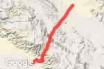
Back Door into Capital ReefGravel route from FR 168 to Pleasant Creek Rd, Torrey, Wayne County, Utah "Challenging back way into Capital Reef. Expect sand and rocky sections. Not easy and no water. Expect scenery and solitude!" 1 |

3 mi
gravel
|

28 mi
gravel
|

41 mi
gravel
Poison Springs Wash Rd to NP730Gravel route from BLM 15000 to NP730, Hanksville, Garfield County, Utah "This would be an epic route. Up and down through canyon after canyon. You'll need to wade across the Dirty Devil River. You'll probably have to push a few steep climbs... but the scenery is amazing. The condition of the road is all over the map... up, down, hard-pack, rocky, some sand. " 2 |

31 mi
gravel
NP633Gravel route on NP633, Lake Powell, Garfield County, Utah "Rises from South to North. Fair easily graded road, not too much to worry about in terms of sand or rocks. Nice riding. Of course conditions could vary year to year. This could access many other areas and trails, but this is the only section I have seen with my own eyes and can vouch for. Could be used to go further into Canyonlands to access Doll House area, but it does get way more technical North of the intersection with NP730." 1 |

4 mi
gravel
Callegas Creek RoadGravel route from CA-1 to Callegas Creek Rd, Camarillo, Ventura County, California "East Flat Connector between Portrero and PCH. (I am not sure about the legality of access. Signage is unclear. For this reason, avoid the parallel road on the East side of the creek due to proximity to private ranch.)" |

1 mi
gravel
Hell Hill (Very Steep!)Gravel route from Overlook Trail to Wood Canyon Rd, Malibu, Ventura County, California "A Very Steep Hill... but fairly smooth gravel." |

2 mi
gravel
Mulholland to The HubGravel route from Temescal Fire Rd to Temescal Canyon Fire Rd, Los Angeles, Los Angeles County, California "Steep pitch to The Hub" |

4 mi
gravel
Topanga to The HubGravel route from Entrada Rd to Backbone Trail, Topanga, Los Angeles County, California "Prolonged, sometimes steep, climbing from Topanga Canyon Rd" |

13 mi
pavement
Ojai Valley Trail to Ventura River TrailPavement route from Ojai Valley Trail to Ventura River Trail (Ojai Valley Trail Extension, Ventura, Ventura County, California "Nice and Easy paved bike path connecting Ventura and Ojai" |

4 mi
dirt
Calabasas Peak Mtwy Stunt to Old TopangaDirt route from Stunt Rd to Calabasas Peak Mtwy, Topanga, Los Angeles County, California "Prolonged and VERY steep climbing from Stunt Road at the West end." |

8 mi
dirt
'Dirt' MulhollandDirt route on Mulholland Dr, Los Angeles, Los Angeles County, California "Ridgeline fireroad" 1 1 4 |

3 mi
dirt
Calabasas Peak Mtwy to Red Rock RdDirt route from Calabasas Peak Mtwy to Red Rock Rd, Topanga, Los Angeles County, California "Pretty steep climbing up and over to/from Stunt. Scenic riding through Red Rock area near Old Topanga" |

3 mi
dirt
Summit to Summit MtrwyDirt route from Summit to Summit Mtwy to Summit to Summit Mtrwy, Topanga, Los Angeles County, California "Ridgetop connector between Old and 'New' Topanga. Grades are very moderate." |

2 mi
gravel
Old City Creek RdGravel route on Old City Creek Rd, Running Springs, San Bernardino County, California "A great way to drop down into Old City Creek from Highway 330." |

17 mi
gravel
Owens River Rd to Whitmore Tubs RdGravel route from Owens River Rd to Whitmore Tubs Rd, Mammoth Lakes, Mono County, California "Loop out through open Upper Owen's Valley. Gravel road. " 3 |

22 mi
gravel
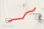
Pinnacle RdGravel route on Pinnacle Rd, Ridgecrest, San Bernardino County, California "Connecting 395 to Trona Pinnacles. Beautiful rock formations. Road conditions vary along the route and with weather, etc." |

5 mi
gravel
Rainbow-Basin LoopGravel route on Fossil Bed Rd, Barstow, San Bernardino County, California "Decent gravel Looping through Rainbow Basin. Nice rock formations, some narrow canyons." |
8 mi
gravel
Fremont Peak RdGravel route from Fremont Peak Rd to Hoffman Rd, San Bernardino County, California "Decent gravel road from 395 to Cuddie Back Dry Lake" 1 |

9 mi
dirt
Sisar Rd to Sisar Canyon RdDirt route from Sisar Rd to Sisar Canyon Rd, Ojai, Ventura County, California "Long Long Steady Climb... better have your climbing gears." |

4 mi
dirt
Grasslands Trail to Crags DrDirt route from Grasslands Trail to Crags Dr, Agoura Hills, Los Angeles County, California "Mixed trail, fairly smooth with a few ups and downs. There is one rocky, very technical section in the middle. Easily walked if you're not up to the challenge." 1 |

4 mi
dirt
Las Virgenes TrailDirt route from Las Virgenes Rd to Mulholland Hwy, Agoura Hills, Los Angeles County, California "Mixed trail, fairly smooth with a few ups and downs." |
11 mi
gravel
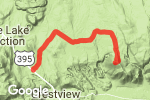
Bald Mountain RdGravel route from US-395 to Forest Rd 2S162, Mono County, California "Pretty straight-forward wide gravel road through pine forest from 395 to the top of Bald Mountain. Only gets a little challenging in terms of rocks and steepness at the very end with a couple of switchbacks to the top. Awesome panorama view from the top." 1 |

6 mi
dirt
Gooseberry MesaDirt route from Main St to Unnamed Road, Virgin, Washington County, Utah "Route out to the point on Gooseberry Mesa. Great views from the point looking West. The route is navigable much further West than the tool would let me enter. Expect dirt road with a few rocky sections. Expect sand as you move further West. Good camping along the rim on both the North and South rims of the mesa. " |

9 mi
dirt
Smithsonian Butte RoadDirt route from Main St to Bridge Rd, Rockville, Washington County, Utah "Connecting route between Hwy 59 and Hwy 9. Expect a gradual climb from the South and a much steeper climb if coming from the North. Can get very muddy, avoid if wet. Expect a few rocky steep sections and some ruts left over from wet weather periods." 1 |

27 mi
gravel
John's Valley through Casto Canyon to Red Canyon/Hwy 12Gravel route from Toms Best Spring Rd to UT-12, Panguitch, Garfield County, Utah "John's Valley portion traverses open range country with spectacular views. As you move West, things narrow as you drop down into Casto Canyon. Casto features red rock walls and hoodoos similar to Bryce. East end exits out to 'Dump Road' near Red Canyon / Highway 12. Food, water etc is available there." 2 1 |

11 mi
gravel
Pine Lake RdGravel route on FR 132, Antimony, Garfield County, Utah "Nice road between Barney Top and John's Valley. Passes a nice campground at Pine Lake with toilet facilities. Busy or quiet depending on the season." |

12 mi
dirt
Barney Top to Powell PointDirt route from FR132 to Powell Point Trail 34006, Antimony, Garfield County, Utah "Mixed condition trail along ridge out to Powell Point through Aspen forest. Expect climbing, mud, smooth wet, dry, hot, cold, snow, rocks... everything! But very doable in good weather. The view from Powell Point is amazing." |

15 mi
gravel
Old Escalante Rd to Barney TopGravel route from Main Canyon Rd to FH 17, Antimony, Garfield County, Utah "Wonderful climb from Escalante to Barney Top at 10,000 feet." |

26 mi
dirt
Hole in the Rock Rd- Escalante to Dry Fork SlotsDirt route on BLM200, Escalante, Kane County, Utah "Nice road down to Dry Fork Slots, continues South to "Hole-in-the-Rock" but conditions get more challenging. Good slots to explore at Dry Fork Slots. Don't miss the 1/4 mile side trip in to see Devil's Garden also. Avoid in wet conditions. Always check road conditions at BLM office. Can be easy or impossible depending on weather and mud." |

16 mi
dirt
Forest Rd 109, Tropic Reservoir to HatchDirt route from Forest Rd 109 to E 100 N St, Hatch, Garfield County, Utah "Nice quiet back road between Tropic Reservoir and Hatch/ Hwy 89. Nice road in dry conditions. One of the few dirt routes that connect between this 'middle step' at Tropic Reservoir and Highway 89 at Hatch. Good back-country camping spots in the meadows just West of Tropic Reservoir." |

9 mi
dirt
E Fork Rd/FR 087Dirt route on FR 087, Bryce, Garfield County, Utah "Mostly flat open terrain, smooth road between 12 and Tropic Reservoir." |

33 mi
dirt
Skutumpah RdDirt route on BLM500, Kanab, Kane County, Utah "Nice road and mixed scenery. Avoid this road when wet! As with all dirt roads in this region, it will turn to goo. There are some nice slot canyons along the Northern half of this route which provide nice opportunities for hiking and exploration." |

15 mi
gravel
Glendale Bench RdGravel route from Glendale Bench Rd to BLM 600, Kanab, Kane County, Utah "Nice road, but beware wet weather as it will turn to goo." |

15 mi
gravel
Sulphur Mountain RdGravel route from Sulphur Mountain Rd to Sulphur Mountain Rd, Ojai, Ventura County, California "Well graded fire-road with a little pavement at either end." 3 |

5 mi
singletrack
Backbone Trail (Etx Meloy/Yerba Buena to Yerba Buena/Circle X)Singletrack route on Backbone Trail, Malibu, Ventura County, California "Fun flowy single-track, great views. Some rocks, and loose dirt." |

4 mi
dirt
Backbone Trail to Backbone Trail/Etz Malloy Fire RoadDirt route from Backbone Trail to Etz Malloy Fire Road, Malibu, Ventura County, California "Mixed Single-track (East Half) and ridge-top fire road (Western Half). There's a new single-track trail that bypasses the gates at the Western End and takes you out to Yerba Buena Rd. Fairly well graded. The connector has a VERY steep hill, but it's not too long, so walk it if you need to." |

1 mi
singletrack
Backbone TrailSingletrack route from Clark Ranch Rd to Backbone Trail, Malibu, Los Angeles County, California "Nice fairly smooth singletrack" |

2 mi
pavement
Ranch Center RdPavement route from Ranch Center Rd to Ranch Center Rd, Malibu, Ventura County, California "A bit of a climb from either direction. Road surface is a decomposing asphalt roadway. Watch out for pot holes with square edges." |

2 mi
gravel
Wood Canyon RdGravel route from Wood Canyon Rd to Ranch Center Rd, Camarillo, Ventura County, California "Fairly smooth and well graded route through a shady canyon. There are a few dips through creek beds." |