
Johnny The Cider
Johnny has contributed 3 routes spanning 93 miles of routes in Yukon Territory and Alaska.
Member since September 14, 2019.
0 total upvotes
2 total comments

5 mi
gravel
Arctic Valley RdGravel route from Arctic Valley Rd to Ski Bowl Rd, Anchorage, Anchorage, Alaska " This road is a publicly accessible road on a portion of the Fort Richardson army base. It is paved from the exit to when the road starts gaining elevation. From there, it is dirt and gravel until it reaches the ski lodge at the top end. The dirt is packed, the gravel is loose and sometimes large. There are quite a few sections of heavy washboard. This is a well traveled side road that many people in Anchorage go up to some times to look at some scenery. In the winter there is also the Arctic Valley ski area at the top end of the road. Mind you, the whole time you are on a military installation. If you bring your weed, or whatever, on that land and get busted somehow, you will probably get a federal charge or federal jail time. There is an old derelict missile silo at the top of one of those mountains. When I worked on the base on security they would always dispatch security officer is up to that area because people would try to jump the fence and go see the missile silo. They always got caught. From what I hear, they almost always get a federal charge. Don’t go in there unless you want to get arrested. This road is essentially a dead-end road with several restricted roads coming off of it, apparently only for military use. You can hike in the area if you are a civilian but you have to go get a pass at the Fort Richardson main gate office. Overall, this road is a good opportunity for scenic pictures of Anchorage and the Anchorage bowl. On a clear Day you can see clear across the turn again arm and the cooking light to the mountains on the other side. " |
60 mi
gravel
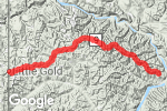
YT-9 SGravel route on YT-9, Yukon, Yukon Territory " From the Canadian border to outside of Dawson City, Yukon Territory, Canada, The Top of The World Highway is mostly dirt but I would call it gravel because significant portions of it are gravel. East of the Canadian border for maybe 20 miles is pretty marbly gravel that motorcycles should use caution on. There are other shorter spots with this type of gravel that exist throughout this route. The road starts at the top of the mountains and follows the ridge lines of these mountains for almost the whole way to Dawson city. It’s spectacularly beautiful. You get to see the whole area from up high, sometimes above the tree line. There are no services on this road till Chicken, Alaska so gas up in Dawson city and then gas up and Chicken or Eagle, depending where you’re going. In summer, the road is fairly well traveled for being so remote, because it is a popular road destination for travelers. There is no cell service, at least when I was on it. " |

28 mi
dirt
Taylor HwyDirt route from State Hwy 5 to State Hwy 9, Eagle, Southeast Fairbanks, Alaska " From Chicken, Alaska to Jack Wade junction ( just short of the Canadian border), this portion of the Taylor Highway contains mostly flat packed dirt with some loose gravel in spots. Some potholes and washboards exist. Very beautiful and scenic. Watch out for caribou crossing the road. For being so remote, it’s reasonably well traveled in the summer as it is a road destination for many. There are no services on this portion of the road so gas up in Chicken. " 2 |